Jan 05, 2024

📸 Flashback Friday: Salina Post - The Smoky Hill River - Vol. 23

Posted Jan 05, 2024 3:54 PM
Flashback Friday Logo

Salina Post proudly presents Flashback Friday in partnership with the Smoky Hill Museum. Enjoy a weekly tidbit of local history from the staff at Salina Post and the Smoky Hill Museum as we present "Salina-Flashback Fridays."

By SALINA POST

View of the Smoky Hill River from the Iron Avenue bridge. <b>Image Courtesy Friends of the River Foundation</b>
View of the Smoky Hill River from the Iron Avenue bridge. Image Courtesy Friends of the River Foundation

Originating in the high plains of eastern Colorado, the 575-mile-long Smoky Hill River provides animals with sustenance, gives people a place to recreate, and has served as an economic driver that catapulted Salina into the 20th and 21st Centuries.

1858, Salina's founders chose the city site because of its practical location. The town, located on the westernmost point of the ancient Indian trail, was established as a trading post for prospectors bound for Colorado, westbound immigrants, and Native American tribes.

A drawing / painting of 1867 bridge over the Smoky Hill River on Iron Avenue. The "Imaginary Free Ferry," Phillips Topeka Road. Created by AM Campbell. <b>Image Courtesy Smoky Hill Museum</b>
A drawing / painting of 1867 bridge over the Smoky Hill River on Iron Avenue. The "Imaginary Free Ferry," Phillips Topeka Road. Created by AM Campbell. Image Courtesy Smoky Hill Museum

Early settlers harnessed the power from the flowing river, which soon ran mills that sawed trees into wood and ground grain into flour. Salina's milling industry was born and steadily grew to the third-largest flour-producing city in the world.

READ MORE: Smoky Hill Museum collecting 'river stories'

The river also became the place to celebrate life. Picnics, horse racing, boat trips and swimming enhanced the quality of life and helped build the young community.

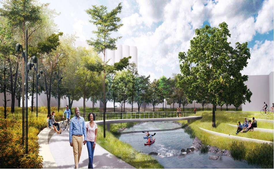
Recreating on the Smoky Hill River

Salina residents play hockey on the frozen surface of the Smoky Hill River. Image c.1950&nbsp;<b>Image Courtesy Friends of the River Foundation</b>
Salina residents play hockey on the frozen surface of the Smoky Hill River. Image c.1950 Image Courtesy Friends of the River Foundation
Adults, children and a dog swim in the waters of the Smoky Hill River c.1910.&nbsp;<b>Image Courtesy Smoky Hill Museum</b>
Adults, children and a dog swim in the waters of the Smoky Hill River c.1910. Image Courtesy Smoky Hill Museum
Salinans skate on the frozen Smoky Hill River in Oakdale park c.1930.&nbsp;<b>Image Courtesy Smoky Hill Museum</b>
Salinans skate on the frozen Smoky Hill River in Oakdale park c.1930. Image Courtesy Smoky Hill Museum
A linen graphic postcard of boaters and water skiing in the Smoky Hill River, Salina, Kansas. On back: "Salina, in the heart of the nation ranks fourth in production of flour. It is also an important manufacturing center." Published by Carroll News Agency, Salina, Kansas. C1950&nbsp;<b>Image Courtesy Smoky Hill Museum</b>
A linen graphic postcard of boaters and water skiing in the Smoky Hill River, Salina, Kansas. On back: "Salina, in the heart of the nation ranks fourth in production of flour. It is also an important manufacturing center." Published by Carroll News Agency, Salina, Kansas. C1950 Image Courtesy Smoky Hill Museum

Waters that brought relaxation and prosperity to the small community also brought devastation. Residents of Salina experienced multiple flood events not too long after the city's establishment.

One of the first floods that impacted the city happened in 1903. The flood, caused by a deluge of 17.13 inches of rain, took place in May.

Flooding of the Smoky Hill River continued over the next several decades, with floods occurring in 1915, 1938, 1941, and 1951.

Photos of Smoky Hill flood events&nbsp;

"residence of Charles Hanly near Walnut Street bridge." July 10, 1904.&nbsp;<b>Image Courtesy Smoky Hill Museum</b>
"residence of Charles Hanly near Walnut Street bridge." July 10, 1904. Image Courtesy Smoky Hill Museum
Downtown Salina c.1920.&nbsp;<b>Image Courtesy Smoky Hill Museum</b>
Downtown Salina c.1920. Image Courtesy Smoky Hill Museum
' SALINA YOUR OPPORTUNITY' arch during the flood in the 1920s&nbsp; at Bishop and Ninth.&nbsp;<b>Image Courtesy Smoky Hill Museum</b>
' SALINA YOUR OPPORTUNITY' arch during the flood in the 1920s  at Bishop and Ninth. Image Courtesy Smoky Hill Museum
Photograph was printed on page 70 in "A Pictorial History of Saline County, Kansas." Wooden foot bridge that was across the A Smoky Hill River, August 1935. This was before the flood of  1938 that took part of the footbridge. Then the 1941 flood destroyed the rest. The man third from the right is Jesse Rothrock. The ford in the upper left was the north end of the crossing. It was at the dead end of Cloud Street in Salina. It was used as a crossing to get to a field of White's. White's daughter, Nell and her husband Floyd Newcomb, lived just west of the field on Cloud on the north side. To the far right hand side of the photo, the foot bridge ends at the south entrance of the crossing. The ford entered the river just west of Bob White's horse barn. People in the area southeast of Salina used the river ford to make their way to Salina to do their trading, coming across what is now the Elks Club, into White's pasture. The wagons would cross on the right side, down river on the east side of the foot bridge.&nbsp;<b>Image Courtesy Smoky Hill Museum</b>
Photograph was printed on page 70 in "A Pictorial History of Saline County, Kansas." Wooden foot bridge that was across the A Smoky Hill River, August 1935. This was before the flood of 1938 that took part of the footbridge. Then the 1941 flood destroyed the rest. The man third from the right is Jesse Rothrock. The ford in the upper left was the north end of the crossing. It was at the dead end of Cloud Street in Salina. It was used as a crossing to get to a field of White's. White's daughter, Nell and her husband Floyd Newcomb, lived just west of the field on Cloud on the north side. To the far right hand side of the photo, the foot bridge ends at the south entrance of the crossing. The ford entered the river just west of Bob White's horse barn. People in the area southeast of Salina used the river ford to make their way to Salina to do their trading, coming across what is now the Elks Club, into White's pasture. The wagons would cross on the right side, down river on the east side of the foot bridge. Image Courtesy Smoky Hill Museum
Aerial postcard pictured in black and white of Salina at the time of the June 5, 1938 flood. Area shown in photo includes Walnut Street eat to and including Oakdale Park.&nbsp;<b>Image Courtesy Smoky Hill Museum</b>
Aerial postcard pictured in black and white of Salina at the time of the June 5, 1938 flood. Area shown in photo includes Walnut Street eat to and including Oakdale Park. Image Courtesy Smoky Hill Museum

The flood of 1938, in particular, was especially catastrophic for the Smoky Hill River Valley. Homesteads, farms and small towns in the area were devastated. Kansas congressional leaders passed legislation in Washington, D.C. that authorized the construction of the Kanopolis dam in 1940. Despite the project's temporary suspension during World War II, the first artificial lake in Kansas, Kanpolis Lake, wasn't completed until 1948.

Despite these safeguards, the river was still susceptible to flooding.

In 1951, following another catastrophic flood, local leaders cut off the channel's flow through Salina. What once was picturesque enough to have the movie "Picnic" filmed on its banks is now a silt-filled ditch.

In 1957, construction began on the diversion channel and levee system by the Corps of Engineers as part of the city's flood protection plan. The structure was completed in 1961.

The original river channel dried up, and Salina's identity with its historic river seemed to fade into history. In 1986 The City of Salina and the Chamber of Commerce conducted a study to determine the desired outcome for the old channel. The result was nearly unanimous - the beautification of the old channel.

During the late 80s and early 90s, the river project was somewhat forgotten and the revitalization project temporarily shelved. Another flooding event happened along the river in 1993.

The Smoky Hill River.<b> Image Courtesy Friends of the River Foundation</b>
The Smoky Hill River. Image Courtesy Friends of the River Foundation

In the mid-2000s, like the city founders who came more than 100 years before them, Salina residents still saw the river as an incredible asset.

The Friends of the River Foundation held its first organizational meeting in 2007. The group's mission is "to strive and restore the natural channel of the Smoky Hill River to its role as an integral part of the aesthetic, recreational, and economic life of Salina."

LISTEN: Jane Anderson, Friends of the River Executive Director

In 2009, the foundation became a 501c3 and collected input from 3,500 residents about what they wanted the Smoky Hill River to look like. In December 2009, the Salina City Commission authorized the preparation of a master plan to guide the restoration and renewal of the Old Smoky Hill River channel.

Salina Downtown, Inc., on behalf of the Friends of the River Foundation and in partnership with multiple private and public agencies, engaged ConsultEcon, Inc. to conduct an economic impact analysis of the Smoky Hill River Renewal Master Plan.

In 2015, the group hired Jane Anderson as executive director to help continue the project for the future. By the following year, the organization pushed to pass a sales tax increase to fund the renewal project.

From 2015 to 2023, the group continued to acquire funding for the project and eventually became a funded partner of the Salina Area United Way in the Summer of 2023.

Friends of the River Foundation Ribbon Cutting - Utilities Dir. Martha Tasker and Pres of Board Brad Stuewe. <b>Photo by Olivia Bergmeier</b>
Friends of the River Foundation Ribbon Cutting - Utilities Dir. Martha Tasker and Pres of Board Brad Stuewe. Photo by Olivia Bergmeier

One chilly morning in October 2023, the Friends of the River Foundation opened the first half-mile portion of the concrete walking path next to the channel.

"This trail is the first construction project of many to come in the near future," Anderson said. "(It) allows the public to have a beginning glimpse of what the Smoky Hill River Renewal Project could bring to this community."

Smoky Hill River Renewal project design for Founders Park in Salina. <b>Image Courtesy Friends of the River</b>
Smoky Hill River Renewal project design for Founders Park in Salina. Image Courtesy Friends of the River