By SALINA POST
In another sign that winter is almost behind us, Monday kicks off the state's annual Severe Weather Preparedness Week.
Kansas Governor Laura Kelly signed a proclamation designating March 1-5 as Severe Weather Preparedness Week in the state. Additionally, the National Weather Service (NWS), the state Division of Emergency Management, and the Kansas Emergency Management Association have teamed up to provide a variety of severe weather preparedness information.
READ: NWS offering Storm Fury on the Plains virtually this year
Barring severe weather on Tuesday, a statewide tornado safety drill will be conducted at 10 a.m. NWS offices serving Kansas will send out a test tornado warning with live Emergency Alert System (EAS) coding at 10 a.m. The test will allow the warning to access the EAS system to ensure that it is relayed through law enforcement and media communication systems, according to information from the state Adjutant General's Department, which oversees the state Division of Emergency Management. The test will also be broadcast on NOAA Weather Radios and some emergency management partners may also sound sirens depending on the weather conditions.
"Everyone is encouraged to participate in the drill by practicing seeking secure, safe shelter from a tornado," NWS in Wichita noted on its website. "We encourage everyone to abide by health and safety guidelines related to COVID-19 during the tornado test which includes staying at least 6 feet from other people when possible and wearing a mask. If that's not possible then simply sheltering in place or discussing where you'd go and what you'd do are other options."
The NWS offices in Wichita and Topeka also plan to focus on a number of severe weather safety topics through the week, including:
Preparedness
Tornado safety
Lightning safety
Hail/wind safety
Flood safety
Kansas tornadoes in 2020
Like most activities in the past year, the number of tornadoes dropped off drastically in 2020, according to information provided by NWS, the state Division of Emergency Management, and the Kansas Emergency Management Association.
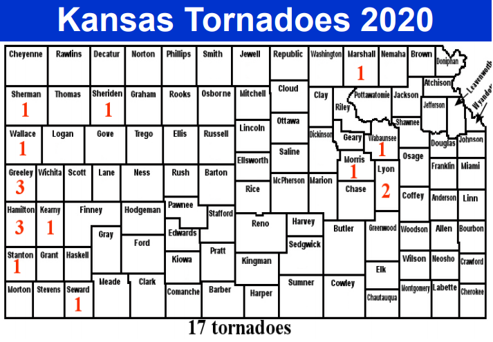
Kansas saw only 17 tornadoes during its 92-day tornado season, which spanned May through August. The first tornado of the year struck Lyon County on the evening of May 14. It was an EF-Unknown that was 25 yards wide and traveled 2.66 miles. The last tornado of the season was an EF-Unknown twister that was 100 yards wide and traveled 1.34 miles through Greeley County on the afternoon of Aug. 14.
"Tornadoes leaving behind no noticeable damage are given an EF-U or EF-Unknown rating. Tornadoes are given a rating based on estimated wind speed. When a tornado does not leave behind damage, it is difficult to near impossible to make a correct wind speed estimate," NWS noted.
The 17 tornado total was 45 below the 1950-2020 average of 62, 71 below the past 30-year average of 88, and 55 below the past 10 year average of 72, according to NWS. Fortunately, no one was killed or injured during any of the 2020 tornadoes.
The longest tracking tornado was an EF1 tornado that tore through 6.2 miles of Seward County on July 1. That tornado also was the strongest of the 2020 twisters.
Greeley and Hamilton counties claimed the title of most tornadoes in a county with three each. Additionally, May 21 saw the most tornadoes in one day at six, while the month of May garnered the most tornadoes in one month title with 11.
Other severe weather in 2020
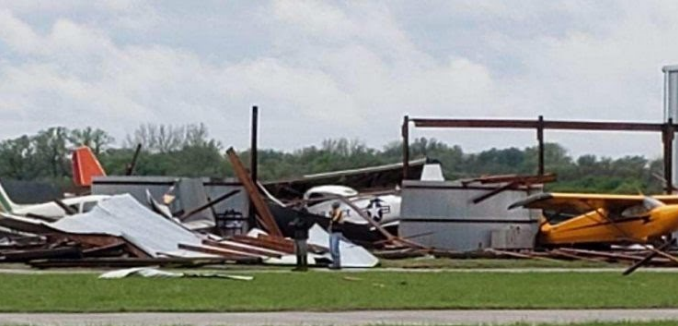
NWS in Topeka recalled early morning May 4 supercell thunderstorms that formed in north-central Kansas and tracked southeast across much of NWS-Topeka's service area. The storms produced numerous instances of tennis ball- to baseball-sized hail during the morning, as well as sporadic damaging wind gusts in excess of 70 mph, NWS-Topeka reported. The Abilene Municipal Airport experienced what appeared to have been a downburst of winds that damaged or destroyed several hangers and aircraft, NWS-Topeka noted.
"The storms continued to produce very large hail and sporadic damaging winds through the late morning hours as they tracked southeast across the area. The event was unusual in the sense that most severe weather tends to begin in the late afternoon and last into the evening, whereas the storms on May 4th developed around 6AM and moved out of the area by noon ending the severe weather!" NWS-Topeka explained.
Late June through late July saw heavy rains and flooding wash through parts of our area.
NWS in Hastings, Neb., recalled heavy rains on June 26-27.
"Anywhere from 2” to 6” of rain was recorded including 5.05” just northeast of Beloit. This prompted relatively minor flooding and drove the Solomon River out of its banks at Beloit with a crest of 22.4 feet (flood stage is 20 feet)," NWS-Hastings noted.
On July 26, more rain soaked Jewell and Mitchell counties, with rainfall totals of four to seven inches recorded.
"Just north of Randall, a driver had to be rescued when their car left the road and ended up in the ditch after encountering water over the road," NWS-Hastings added.
Extremely large hail also pummeled Jewell and Mitchell counties on Aug. 14.
"Jewell County was hit the hardest with copious amounts of tennis to softball sized hail. The large hail caused extensive damage to homes, vehicles and area crops. Hailstones measured at 4” in diameter in Mankato and two miles north of Jewell. The Jewell County EMS Director’s vehicle incurred major damage including a shattered windshield. Total damage for this event was likely in the millions of dollars," NWS-Hastings explained.
Hail also battered parts of NWS-Wichita's service area on May 3-4, including golf ball-sized hail near Lincoln and New Cambria.
NWS-Wichita also reported on an approximate 10-mile-wide band of heavy snow that covered parts of central and north-central Kansas in the early morning of Feb. 25. Snow totals ranged from two to 13 inches.
To see the entire information packet from NWS, the state Division of Emergency Management, and the Kansas Emergency Management Association (19-page pdf), click here.
. . .
Feature photo of a tornado north of Solomon on May 16, 2016, courtesy Ks0stm/Wikimedia Commons, CC BY 4.0, via Wikimedia Commons.