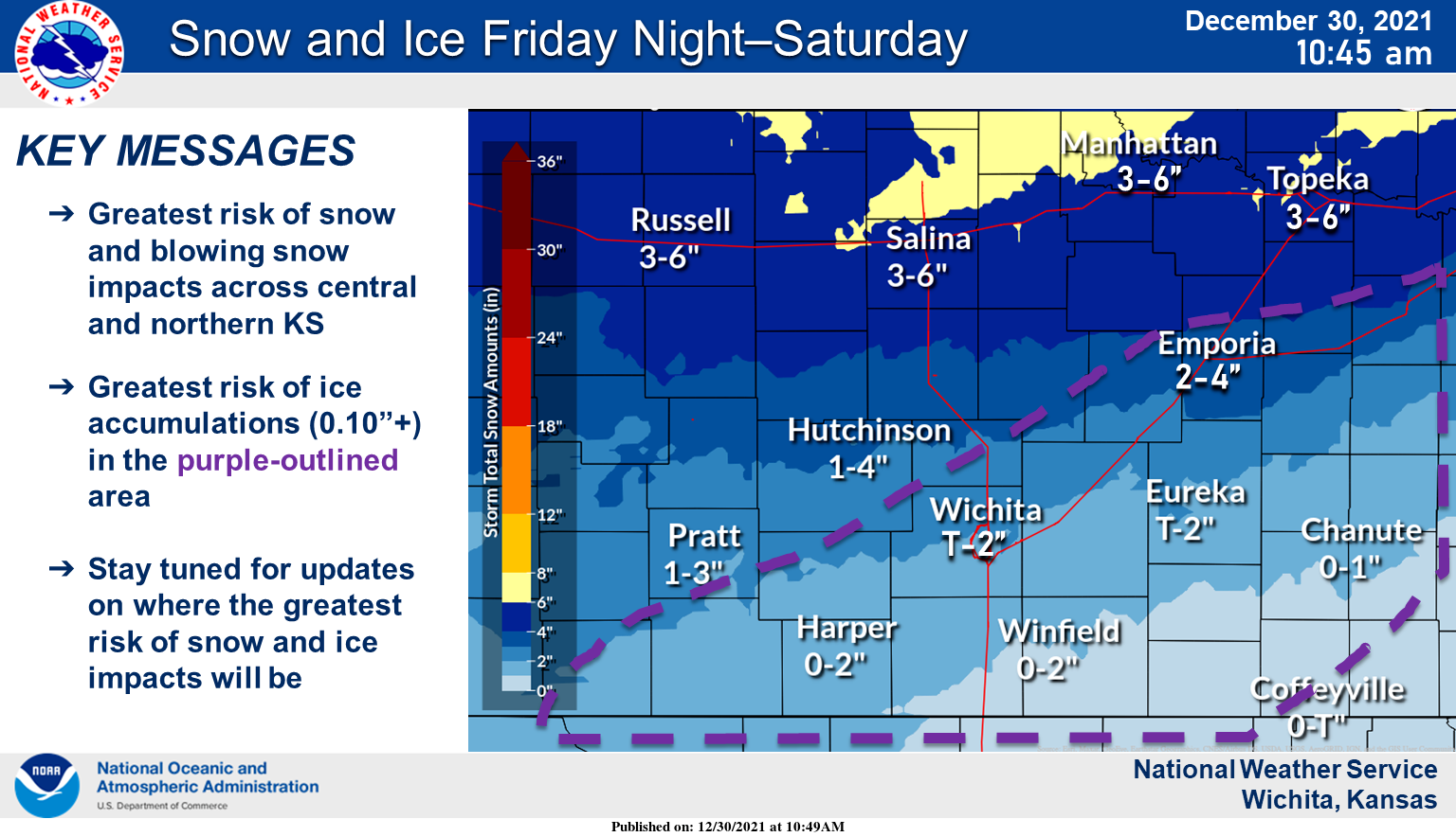
UPDATE 11 a.m. Thursday: The National Weather Service has provided a map showing forecast snow and ice amounts. See below.
. . .

From THE NATIONAL WEATHER SERVICE
Winter storm watches have been issued for counties in our area.
The National Weather Service in Wichita has issued a winter storm watch in effect from late Friday night through late Saturday night for the following counties in our area.
Ellsworth County
Lincoln County
Marion County
McPherson County
Saline County
A mix of freezing rain, sleet and snow, with total snow accumulations of 4 to 6 inches and ice accumulations of approximately a tenth of an inch are possible. Winds could gust as high as 35 mph.
Uncertainty lies in the progression of the cold air. How fast the cold air moves in will determine how high the impacts will be. Changes in the forecast are likely.
Plan on slippery road conditions. Patchy blowing snow could significantly reduce visibility. The cold wind chills as low as 15 below zero could result in hypothermia if precautions are not taken.

The National Weather Service in Topeka has issued a winter storm watch in effect from late Friday night through Saturday evening for the following counties in our area.
Clay County
Cloud County
Dickinson County
Ottawa County
Republic County
Widespread wintry precipitation is expected across the region. Total snow accumulations of 2 to 8 inches and ice accumulations of around one tenth of an inch possible. Winds could gust as high as 35 mph.
Plan on slippery road conditions. Patchy blowing snow could significantly reduce visibility. The cold wind chills as low as 20 below zero could cause frostbite on exposed skin in as little as 30 minutes.
Very cold wind chills Saturday and Saturday night could be dangerous for vulnerable populations and those that may become stranded in their vehicles.
The National Weather Service in Hastings, Neb., has issued a winter storm watch in effect from late Friday night through Saturday evening for the following counties in our area.
Jewell County
Mitchell County
Heavy snow is possible. Total snow accumulations of 4 to 6 inches possible. In addition, strong northerly winds of 20 to 25 mph with gusts to around 30 mph may result in blowing and drifting snow along with reduced visibilities. Wind chill values by Saturday morning could be as low as 15 to 25 degrees below zero.
The brunt of this storm system is still a few days away and thus at least some changes to the forecast are likely. Therefore, please keep up to date with the latest details if you have travel plans over the holiday weekend.
Plan on slippery road conditions. The cold wind chills as low as 25 below zero could cause frostbite on exposed skin in as little as 30 minutes.