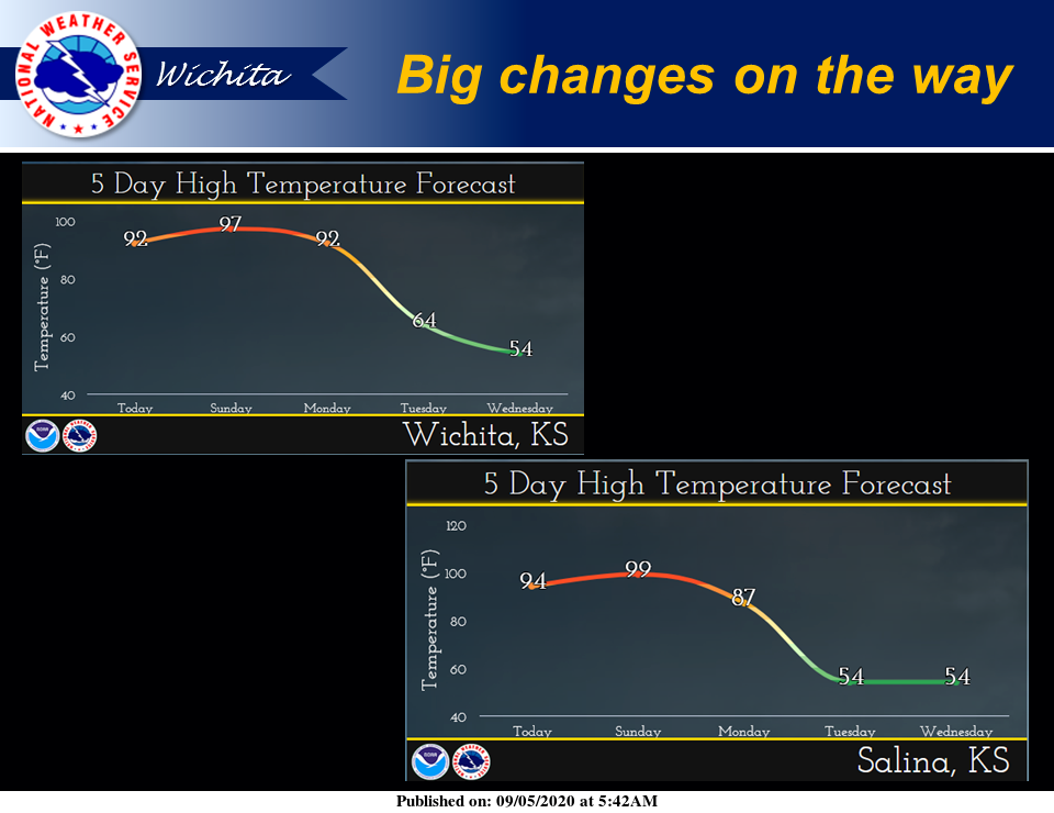
We're in for a dramatic shift in temperatures next week as a strong cold front moves into the area.
According to the National Weather Service (NWS) in Wichita, high temperatures Tuesday and especially Wednesday will be 30 to 40 degrees colder than high temperatures today and Sunday!
Here is the forecast from NWS:
Today
Sunny, with a high near 94. South wind 5 to 14 mph, with gusts as high as 18 mph.
Tonight
Clear, with a low around 72. South wind 11 to 16 mph, with gusts as high as 24 mph.
Sunday
Sunny and hot, with a high near 99. Breezy, with a south southwest wind 16 to 26 mph, with gusts as high as 36 mph.
Sunday Night
Mostly clear, with a low around 69. South southwest wind 6 to 14 mph, with gusts as high as 26 mph.
Labor Day
Sunny, with a high near 90. East wind 6 to 10 mph, with gusts as high as 23 mph.
Monday Night
A chance of showers and thunderstorms. Mostly cloudy, with a low around 51. Breezy. Chance of precipitation is 50 percent.
Tuesday
Showers and possibly a thunderstorm. High near 56. Breezy. Chance of precipitation is 80 percent.
Tuesday Night
Showers likely and possibly a thunderstorm before 1 a.m., then a chance of showers and thunderstorms after 1 a.m. Mostly cloudy, with a low around 43. Breezy. Chance of precipitation is 70 percent.
Wednesday
A 50-percent chance of showers. Mostly cloudy, with a high near 55.
Wednesday Night
A 30-percent chance of showers, mainly after 1 a.m. Mostly cloudy, with a low around 44.
Thursday
A 30-percent chance of showers. Partly sunny, with a high near 64.
Thursday Night
A 30-percent chance of showers. Partly cloudy, with a low around 47.
Friday
A 30-percent chance of showers. Mostly sunny, with a high near 68.